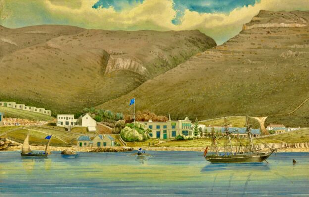
Today we received welcome news from our dear friend Bunny on the east coast of South Africa in Simon’s Town. I marvel at the brilliance of such exotic travel! The venture to the area illustrates one-quarter of her life. The memories – both good and bad – stimulated by this compelling recall are no doubt unsurpassable. I suspect much has changed no matter where one goes, but the antiquity of Simon’s Town likely preserves much of what has always been there.
For more than two centuries, it has been a naval base and harbour (first for the British Royal Navy and now the South African Navy). The town is named after Simon van der Stel, an early governor of the Cape Colony.
As with all travel the subject of returning to one’s primary residence is not far removed from the on-going narrative. One needn’t hurry the procedure – and hopefully the more desirable restraint lingers whilst the roving images are bright and commanding – but soon the urge to conjoin with one’s own space manifests itself in less than urgent appeal. The stimulus may provoke philosophic rumination about both the past and the future. What if things had been different? What if my heartfelt decisions had succumbed to sterile reasoning?
These internal streams of thought are rightfully manipulated by the practical decision to get on with life. There is unquestionably a remarkable dignity to closure and forgiveness, applied not only to others but also to oneself. So much of our lives is best rendered as featureless; otherwise we simply stumble and tumble upon one or another obstruction. Paradoxically the species survives; progress continues. Like a darting school of fishes or a buzzing swarm of bees, our individual record of behaviour is often lost in the appearance of community and contribution. It is a small compliment from which some survive and others perish; the flamboyance of life is diluted by the metaphoric complications of water and air that enfold about us.

Featured image: Wikipedia
Okay – using the map below (click on it to enlarge it) which shows all but the last northeastern part of the coastline, let me explain.
First of all it helps if you think of South Africa as if it were shaped like a bowl, and starting on left hand side of this bowl is where you’ll find Cape Town and the Western Cape Province which borders on the South Atlantic Ocean. Then moving along the base of the bowl starting at False Bay which is just south of Cape Town, (i.e. the bottom left corner of the bowl), head eastward (i.e. to your right) past Cape L’Agulhas, the true southernmost tip of Africa by the way, all the way to Gqeberha (formerly Port Elizabeth). The ocean along this south coast stretch is the Southern Ocean which goes all the down to the Antarctic. On reaching Gqeberha, you are now in what is called the Eastern Cape. and from here the coast starts to swing north and continues north eastward on what is geographically the East Coast with cities such as East London, Durban etc. and where you are now travelling along the Indian Ocean.
I think perhaps your confusion may have come from looking at a map that contains False Bay which is a very big body of water and as Simon’s Town is on the left side of the bay, you may have surmised that the other side was the east coast. However, this is definitely not so and to give you an idea of scale, if you were to drive the coast road (aka the Garden Route) from Cape Town to Durban, it is approx. 1,800 kms. Hope this helps.
Fi
P.S. Fun fact: Gqeberha is a Xhosa word and the ‘q’ is a clicking sound. The ‘x’ in Xhosa is also a click. Xhosa is an offshoot of Zulu which I learnt to speak when I lived in northern Zululand in the mid-1970s. On the map below if you look at the very last name written in the top right corner of the map which says Hluhluwe, I lived about 20 km north and inland from it. Learning the 3 clicks of this language (C, Q, X, ) was a real challenge, often with hilarious results because if you applied the wrong clicking sound, it could change the meaning of a word. For example, I once asked our gardener to please chop some wood for the firebox (we didn’t have electricity on the farm and had a wood burner for hot water and a wood-burning stove), but I got the click wrong and about 10 minutes later I heard an almighty uproar coming from the henhouse. Thinking a snake or a mongoose had gotten in, I grabbed my gun and rushed to the coop, only to find the the gardener busy wringing chickens necks! Apparently, he thought I wanted him to chop chickens, not wood. I then found myself with 2 dead chickens, and not having refrigeration (only a paraffin icebox which was full), I had to get the cook to pluck and cook them while I rang round the neighbours to see who was free to come to dinner! Only in Africa!!
Hello, Fiona!
Thank-you for your instructive email. Yet I am puzzled because I did of course have a preliminary look at Simon’s Town on Google Maps. This led me to believe, overall, it is on the east side of South Africa though it may be on the west side of the peninsula. I am therefore uncertain how this gets us to the west coast of South Africa. Perhaps it is just another example of silly differences.
May I trouble you to correct me?
Billy
Hugs & Kisses
I’ve just been reading about your friend Bunny being in South Africa in Simon’s Town (know it well and it’s a lovely spot). Being a stickler for geography, I’d like to cheekily point out that Simon’s Town is not on the east coast of the country. It is on the east side of False Bay which is just south of Cape Town and is the eastern edge of the Cape Peninsula, which terminates in the Cape of Good Hope. All of this is very much on the West coast of SA. My parents spent many happy winters up until my father died in 2002, in a house they rented in Hermanus which is on what is known as the Garden Route and is just over 100km from Cape Town. Besides being home to SA’s navy, Simon’s Town is also famous for nearby Boulders Beach which is home to a colony of endangered Jackass Penguins.
Here endeth the lesson!!!
xo
Fi
Sent from my iPad